Routes & nearby · Pai, Mae Hong Son
Boon Ko Ku So Bamboo Bridge near Pai
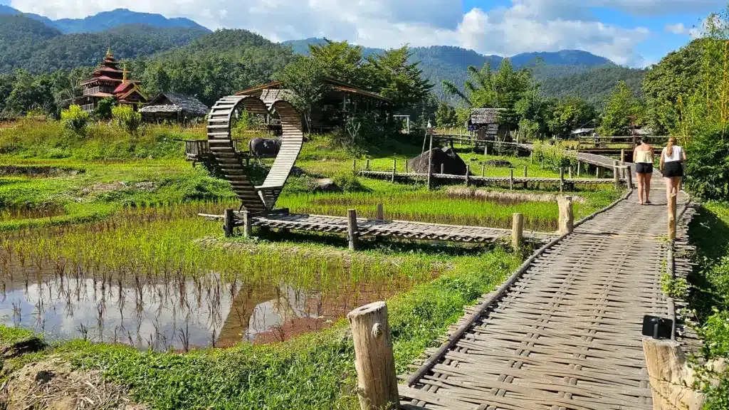
The long bamboo walkway crosses farmland and rice fields in the Pai countryside. Views change from lush green during the growing season to dry harvested fields; remain on the walkway and respect the land and local temple setting.
About Boon Ko Ku So Bamboo Bridge and visitor access
Boon Ko Ku So Bamboo Bridge is a separate attraction in Pai District, not part of the Pai Canyon ridge trail. Local access, maintenance, vendors and any entrance rules are managed according to the relevant site arrangements. Follow posted notices and staff guidance at this location; the forest recreation project described for Kong Lan must not be assumed to operate this separate place.
Tourism Authority of Thailand visitor information ↗History and character
The bamboo walkway links parts of the rural rice-growing landscape and temple surroundings. Its cultural interest lies in how local paths, farmland and community activity meet, rather than a monumental stone structure.
What to observe
Frame the bamboo lines receding across the fields and watch for changing rice colours. Walk carefully where bamboo is wet and do not step off onto cultivated land.
Boon Ko Ku So Bamboo Bridge · Google Maps ↗Essential visitor information
Location
Boon Ko Ku So Bamboo Bridge, Pai, Mae Hong Son, Thailand
Type of attraction
Independent cultural or nature attraction near Pai
Entry
Fees and local services, if any, are determined at this attraction; do not apply Pai Canyon’s free-entry rule.
Suggested duration
About 30–90 minutes; allow for travel
⚠ Check any local closures and route conditions on the day of travel.
Explore the place
The countryside around Pai combines temples, agricultural landscapes, waterways and mountain viewpoints. Interpret each place on its own terms and respect religious, ecological and local community rules.
Visitor recommendations
The long bamboo walkway crosses farmland and rice fields in the Pai countryside. Views change from lush green during the growing season to dry harvested fields; remain on the walkway and respect the land and local temple setting.
Opening hours
Visiting hours depend on the specific attraction and season; check the current entrance notice before travelling.
Tickets and prices
Fees and local services, if any, are determined at this attraction; do not apply Pai Canyon’s free-entry rule.
Getting there
Travel from Pai town to this attraction’s own Google Maps pin. Check rural road conditions and your return transport before leaving.
What makes it special
Frame the bamboo lines receding across the fields and watch for changing rice colours. Walk carefully where bamboo is wet and do not step off onto cultivated land.
History, landscape and local culture
The bamboo walkway links parts of the rural rice-growing landscape and temple surroundings. Its cultural interest lies in how local paths, farmland and community activity meet, rather than a monumental stone structure.
Step-by-step walking route
- 01
Confirm the attraction name, map location and access conditions before leaving Pai town.
- 02
Explore its main viewpoint or visitor path at an unhurried pace.
- 03
Return safely or connect with Pai Canyon only if weather and daylight permit.
Suggested visit sequence
- 01
Check the weather and road conditions before leaving Pai town.
- 02
Park responsibly, walk to the broad first viewpoint and assess the ground.
- 03
Take photographs from stable ground and return before darkness.
Before you visit
Check any local closures and route conditions on the day of travel.
Photography positions
Use broad, safe paths to show the characteristic landscape. Check with people before portraits and do not enter restricted or cultivated areas for photographs.
Where to stay
Pai town is the most convenient base for meals, transfers and day trips into the surrounding countryside.
Visitor reviews
Ratings shown here belong to Pai Canyon itself, not to other nearby attractions.
Open this place on Google Maps ↗Pai Canyon landscape photographs
Visitor questions
Is Pai Canyon suitable for everyone?
The first overlook is a shorter visit, but even the approach can be uneven. Narrow exposed ridges are optional and unsuitable for some visitors.
Can I visit after rain?
Wet red-earth paths are slippery and exposed edges can erode. Stay off narrow ridges after rain or storms.
Where is the correct map location?
Use the Pai Canyon Google Maps place link below. Nearby attractions require their own separate map search.
Location and navigation
Boon Ko Ku So Bamboo Bridge, Pai, Mae Hong Son, Thailand
Open this place on Google Maps ↗